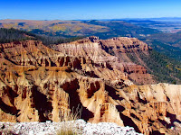
Standing at the rim of Cedar Breaks
National Monument, you gaze into a desert of colorful cliffs and pinnacles. If
you had visited this area sixty million years ago, however, you would have
found yourself treading water in a body of water the size of Lake Erie,
surrounded by hills and mountains. The geology exposed at Cedar Breaks reveals
the powerful forces of change that have given rise to today’s remarkable
landscape.
 |
| Iron & manganese produce the red and purple colors |
The End of the Ancient Seas
 |
| The lake that once covered this area was 250 miles long and 70 miles wide |
During the Cretaceous period, 144-65 million years ago,
the North American continent was slowly drifting towards the southwest, driven
by the spreading of the ocean floor. A shallow arm of the sea stretched across
most of what is now Texas, Oklahoma, Kansas, Nebraska, North and South Dakota,
Colorado, Utah, Arizona and New Mexico. About 105 million years ago, the plates
of earth’s crust changed direction and speed. As the heavy Pacific plate
plunged under the lighter continental plate at a more rapid rate, it compressed
the western margin of the continent. Massive sections of the earth’s crust
slowly moved eastward along low-angle “thrust faults.”
This period of faulting, known as the Sevier
Orogeny, formed a chain of mountains to the west of what is now Cedar Breaks.
About 80 million years ago, as the Sevier mountains began to erode, a second
mountain-building event began to the east. The Laramide Orogeny lasted 40
million years, causing the Cretaceous seabed to lift and drain, and leaving the
Rocky Mountains and such features as the San Raphael Swell, the Waterpocket
Fold of Capitol Reef, and the Monument Upwarp in its wake. The only traces of
the Cretaceous seaway that remain in the area today are the marine sandstones
and shales of the Straight Cliffs Formation found in the canyon below Cedar
Breaks.
 |
| NPS Photo |
A Great Lake
The result of these uplifts to the east and west
was the creation of a large lake basin, 70 miles wide and 250 miles long—about
the size of present-day Lake Erie. Starting about 60 million years ago, streams
flowing from the surrounding highlands washed sand, silt and mud into the
basin. Algae living in the lake incorporated calcium carbonate (CaCO2) into
their body structures. When they died, their remains left thick deposits of
carbonate mud on the lake bottom. Freshwater snails fed in the muddy ooze.
Periodically, the lake would dry up, leaving a
level plain where soils formed, plants grew, and insects such as ants and wasps
burrowed into the dry sediments. Streams ran across the basin, leaving
lens-shaped sand and gravel deposits. Then the lake would fill with water and
deposition would begin again, adding more layers of sediments. Deposition
continued for 20 to 25 million years, gradually filling up the basin as the
surrounding highlands wore down. Trace amounts of iron derived from the source
rocks combined with oxygen and water, “rusting” the sediments into warm red,
orange, and yellow hues. Oxidized manganese stained some sediments purple.
These sediments eventually hardened, becoming the siltstones, sandstones, and
limestones of the Claron Formation.
 |
| Cedar Breaks |
Eruptions and Ash Falls
About 30 million years ago,
volcanoes erupted first to the west and then to the north of Cedar Breaks,
spewing ash into the atmosphere. Some of this ash settled into the dwindling
basin left by the Claron lake. The rocks of the Brian Head Formation are
distinguished from the Claron Formation by their volcanic ash content. Further
volcanic eruptions sent hot ash flows racing across the landscape; the ash
welded together and then cooled to become the Isom Formation. Isolated blocks
of this hard reddish-brown to gray rock can be found along the road and on the
Alpine Pond trail. A later series of ash-flow tuffs, known as the Leach Canyon
Formation, can be seen atop Brian Head peak north of the Monument.
Cedar Breaks
Cedar Breaks
